Waterways can be tricky to navigate, especially when you’re not familiar with the area. Lateral markers are essential aids that help boaters navigate safely through channels and avoid potential hazards.
This comprehensive guide will explore the different types of lateral markers, their purpose, and how they indicate safe passage, the direction of navigation, and hazardous areas. So, let’s set sail and dive into the fascinating world of lateral markers!

What are Lateral Markers?
Lateral markers are navigational aids, also known as aids to navigation (ATONs), that are placed along waterways to mark the sides of channels and indicate safe passage.
These markers are essential tools for mariners and recreational boaters, helping them navigate safely through channels and avoid potential hazards like rocks, shoals, or submerged obstacles.
Picture yourself as a first-time boater in a new area. You might be unsure which side of a buoy or marker to pass on or which way to navigate a channel. Lateral markers provide guidance and help you understand the safest route through the water. By following these markers, you’ll be able to navigate safely, whether you’re a seasoned mariner or a recreational boater.
Types of Lateral Markers
Lateral markers can be categorized into two main types: port lateral markers and starboard lateral markers. Both types of markers are essential in providing clear guidance for navigating through waterways. Let’s take a closer look at each type and understand their significance.
Port Lateral Markers
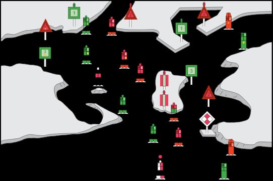
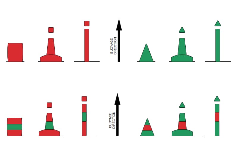
Port lateral markers are found on the left side of a channel when moving upstream, or in the direction of the buoyage system. In the United States and Canada, these markers are typically colored red and may have even numbers displayed on them. Port lateral markers can come in various shapes and sizes, including buoys, beacons, or even floating structures.
Let’s imagine you’re steering your boat up a river, and you see a red buoy with an even number on your left. You now know that you’re looking at a port lateral marker, which means you should keep the marker on your left side as you continue navigating upstream.
Starboard Lateral Markers
Starboard lateral markers, on the other hand, are found on the right side of a channel when moving upstream or in the direction of the buoyage system. In the United States and Canada, these markers are typically colored green and may have odd numbers displayed on them. Like port lateral markers, starboard markers can also come in various shapes and sizes, such as buoys, beacons, or floating structures.
Continuing with our previous example, let’s say you’re still navigating upstream and see a green buoy with an odd number on your right. This green buoy is a starboard lateral marker, which means you should keep the marker on your right side as you continue moving upstream.
By understanding and recognizing these two types of lateral markers, you’ll be able to navigate waterways safely and efficiently.
What do Lateral Markers Indicate?
Lateral markers play a crucial role in providing guidance and information to boaters as they navigate through waterways. They indicate the direction of navigation, safe water passages, and potentially hazardous areas. Let’s delve deeper into the various aspects of lateral markers and their significance.
One of the primary purposes of lateral markers is to indicate the direction of navigation. When moving upstream or in the direction of the buoyage system, boaters should keep port lateral markers (red) on their left and starboard lateral markers (green) on their right. This rule ensures that boaters are navigating safely and correctly through channels and waterways.
Take, for example, the experience of a group of friends sailing in a new area for the first time. By following the lateral markers and keeping the red buoys on their left and the green buoys on their right as they move upstream, they can confidently navigate through the water without the fear of running aground or encountering other hazards.
Safe Waterway
Lateral markers are essential in marking safe water passages. The area between the port and starboard markers represents the safest route for boaters to navigate. By following the markers and keeping them on the correct sides, boaters can be assured that they are traveling through the safest possible path in the waterway.
Imagine a family on a leisurely boat trip in unfamiliar waters. By following the lateral markers and keeping the red buoys on their left and the green buoys on their right, they can enjoy their day on the water without worrying about venturing into potentially dangerous areas or getting lost.
Hazardous Areas
Lateral markers can also indicate potentially hazardous areas in a waterway. These hazards might include rocks, shoals, or submerged objects that could pose a risk to boaters. By marking the boundaries of safe water passage, lateral markers help boaters steer clear of these hazards and maintain a safe course.
Picture a group of anglers heading out for a day of fishing. They might be tempted to cut corners or take shortcuts, but by following the lateral markers, they can be sure they’re avoiding hazards and staying within the safe channel. This way, they can focus on enjoying their fishing trip without worrying about potential dangers.

IALA Maritime Buoyage System: Regions A and B
Navigating international waters can be challenging, especially when different regions have their own buoyage systems. The International Association of Marine Aids to Navigation and Lighthouse Authorities (IALA) established a maritime buoyage system to standardize navigational aids worldwide.
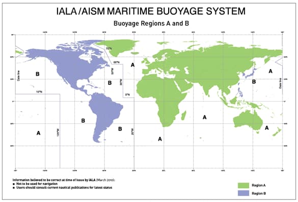
This system is divided into two regions, IALA Region A and IALA Region B, which have distinct lateral marker configurations. Let’s explore these two regions and their differences in lateral marker systems.
Introduction to IALA
IALA is a non-profit organization dedicated to ensuring the safety and efficiency of navigation in international waters. Its primary purpose is to establish standards and best practices for marine aids to navigation, including the maritime buoyage system. The IALA Maritime Buoyage System provides a standardized, globally recognized framework for navigational aids like lateral markers, allowing mariners to navigate safely across the world’s waterways.
Region A
IALA Region A comprises most of the world, including Europe, Africa, Asia, and Australia. In Region A, port lateral markers are colored red and have a can or cylindrical shape, while starboard lateral markers are colored green and have a conical shape. The numbering system follows the same pattern as in the United States and Canada, with port markers bearing even numbers and starboard markers bearing odd numbers.

Region B
IALA Region B includes the Americas, the Philippines, South Korea, and Japan. In Region B, the colors of port and starboard lateral markers are reversed compared to Region A.
Port lateral markers are green with a can or cylindrical shape, and starboard lateral markers are red with a conical shape. The numbering system is consistent with Region A, with port markers bearing even numbers and starboard markers bearing odd numbers.
Understanding the Differences
As a mariner or recreational boater, it’s crucial to be aware of the regional differences in lateral marker systems when navigating internationally. The main distinction between Regions A and B is the color of port and starboard markers, which are reversed. Familiarizing yourself with these differences can help ensure safe and efficient navigation, no matter where you’re sailing.
Adapting to Different Regions
When traveling between IALA Regions A and B, it’s essential to adapt to the different lateral marker systems. Here are some tips to help you adjust:
- Study the region you’ll be navigating in before setting sail. Learn about the specific buoyage system and lateral marker configurations used in that region.
- Consult navigational charts, publications, and electronic aids to verify the region you’re in and the corresponding lateral marker system.
- Maintain a heightened sense of situational awareness when navigating in unfamiliar waters, and always double-check lateral markers to ensure you’re following the correct course.
By understanding the differences between IALA Regions A and B and adapting to their unique lateral marker systems, you can confidently navigate international waters and ensure the safety of your vessel and crew.
Conclusion
Lateral markers are indispensable navigational aids that help boaters navigate waterways safely and efficiently. By understanding the different types of lateral markers (port and starboard) and their roles in indicating the direction of navigation, safe water passages, and hazardous areas, boaters can confidently venture into new waters and enjoy their time on the water without unnecessary risks. Whether you’re an experienced mariner or a recreational boater, it’s essential to familiarize yourself with these markers and their meanings, ensuring you can navigate any waterway with ease and confidence.
What is lateral marks?
Lateral marks, also known as lateral markers, are navigational aids placed along waterways to mark the sides of channels and indicate safe passage. They help boaters navigate safely through channels and avoid potential hazards.
What are the lateral markings of Region A?
In IALA Region A, port lateral markers are colored red and have a can or cylindrical shape, while starboard lateral markers are colored green and have a conical shape. Port markers bear even numbers, and starboard markers bear odd numbers.
What is the use of lateral marks?
Lateral marks are used to guide boaters through waterways by indicating the direction of navigation, safe water passages, and potentially hazardous areas. They help ensure the safety and efficiency of navigation for mariners and recreational boaters.
What is cardinal vs lateral marks?
Lateral marks are navigational aids that indicate the sides of channels and safe passage. Cardinal marks, on the other hand, provide information about the location of a hazard relative to the four cardinal points (north, south, east, and west) and guide boaters on which side of the mark is safe to pass.
What is lateral marks region B?
In IALA Region B, port lateral markers are colored green and have a can or cylindrical shape, while starboard lateral markers are colored red and have a conical shape. Port markers bear even numbers, and starboard markers bear odd numbers.
- Sustainable and Luxurious: Discovering Split’s Yachting Paradise – April 26, 2024
- MarineTraffic vs VesselFinder: Which Is Better Vessel Tracking Service? – February 14, 2024
- Port Costs: A Comprehensive Guide to Port Dues and Fees for Cargo Ships – February 12, 2024


Leave a Reply