Navigating the high seas has become much safer and easier because of the Global Maritime Distress and Safety System. It allowed stakeholders to check and monitor vessels around the globe.
GMDSS(Global Maritime Distress and Safety System) was developed by the IMO (International Maritime Organization), not just in response to multiple disasters but to prevent similar distress incidents.
This system provides an array of options from communication between vessels, to shore-to-ship communication, and alerting equipment designed for search and rescue during a distress situation.
Functions of GMDSS
GMDSS provides that every ship while in port or at sea shall be able to perform basic communication functions. A vessel must be able to transmit ship-to-shore distress alerts by at least two separate and independent methods. This can either be in the form of VHF/MF/HF equipment or EPIRB(Emergency Position Indicating Radio Beacon).
The ship must also be able to receive shore-to-ship distress alerts as well as transmit ship-to-ship distress alerts. The Inmarsat-C equipment can be used to receive shore distress communications while the VHF can be utilized for ship-to-ship transmission and reception of distress messages.
GMDSS requires that all ships must be able to transmit and receive search and rescue coordinating communications. This is crucial during distress situations like Abandon ship and Manoverboard. The vessel in the area must be able to transmit/receive on-scene communications and signals for locating.
Another function of GMDSS is to ensure ships are able to receive maritime safety information. MSI is a broadcast of safety-related information. These include meteorological warnings, navigational warnings, and other vital information such as iceberg sightings.
A ship can use one of two systems available to receive MSI. This is the NAVTEX system and SafetyNET system. Navtex is a terrestrial medium frequency system that broadcasts up to 450 nautical miles. Navtex transmissions are provided for most of the highly populated coastal waters of the globe.
The SafetyNET on the other hand is a satellite-based system that is used to broadcast MSI to all waters of the globe except Sea Area A4. It works via the Inmarsat C system and is used to forward MSI to the 23 NAV/MET areas of the world. The system automatically selects the area in which the vessel is located.
Lastly, as per GMDSS, ships must be able to transmit and receive general communications as well as bridge-to-bridge communications. These may include actions to avoid collision situations using the VHF equipment as well as INM-C for communicating with vessels in farther ranges.
Four Sea Areas of GMDSS
Sea Area A1 is an area that is closest to the shore. This area is within the coverage of VHF coast stations where DSC(Digital Selective Calling) is available. Ships are required to use VHF-capable transceivers with DSC capabilities. Area A1 could extend 30 to 40 nautical miles from a coastal radio station.
Sea Area A2 covers an area that is beyond Area A1. About 40 nautical miles from the nearest coast station, this can extend to 150 nautical miles during the daytime and 180 nautical miles at night. This area provides coverage of at least one MF coast station and continuous DSC alerting. Vessels transiting this area are required to carry VHF and MF equipment.
Beyond Area A1 and A2 is Sea Area A3. It is within the coverage of an INMARSAT geostationary satellite. From 150 nautical miles to 70 degrees North and 70 degrees South of Latitude. Ships navigating in this area are required to carry VHF equipment, Medium Frequency equipment, and Inmarsat satellite.
The area beyond 70 degrees North and 70 degrees South are part of Sea area A4. It is categorized as the polar region as these regions are closest to the poles. Sea area A4 requires High-frequency radio with DSC (Digital Selective Calling) as well as Medium frequency equipment and VHF radios.
GMDSS Documents To Be Carried Onboard
Ship’s Radio License
All ships must carry a radio license to make sure that their radio/communication equipment is working properly and that it is authorized by the vessel’s flag authority to be used. Operation of such equipment is illegal and can be a cause of detainment in some ports.
Having a radio license allows the ship to have her official call sign and MMSI(Maritime Mobile Service Identity). These two pieces of information are normally in conspicuous areas in all communication equipment. A vessel’s radio license contains the ship’s name, call sign and identification number, owner’s name, working frequencies, transmission power, types of transmission, and date of validation.
Radio Operators Certificate
The GOC(General Operators Certificate) is the certificate needed for bridge officers to operate the GMDSS equipment onboard. This is also suitable for offshore radio operators and commercial yacht masters. Holders of this certificate are certified to operate all licensed marine radios equipment, including radiotelephony, DSC, and satellite mobile earth stations.
The GOC must always be kept on the bridge of the ship and will be checked by port authorities including Port State Control.
Safety Radio Certificate
As per SOLAS Chapter 1 Regulation 9, all cargo ships of 300 gross tonnages above are required to carry a Safety Radio Certificate. This certificate certifies that the ship has been surveyed in accordance with the requirements of the regulation. This covers radio installations and its functions complied with SOLAS.
The certificate contains the name of the ship, call sign, port of registry, gross tonnage, sea areas in which the vessel is certified to operate, as well as IMO number. It also indicates the date on which the ship keel was laid and the completion date of the survey.
GMDSS Radio Log Book
The radio log book is an important document that all ships must carry. It records all communications relating to distress, urgency, and safety messages. Entries must include dates and times in Coordinated Universal Time(UTC), as well as details of the vessels involved and their GPS positions.
It is also a record book for weather reports and navigation warnings. Electronic records relating to distress and distress-related communications received onboard via INMARSAT, NAVTEX, NBDP (Narrow Band Direct Printing), and VHF/MF/HF equipment.
Publications
Vessels are also required to carry publications for GMDSS use. These books contain information on coast stations, and ship stations, as well as cell signs and numerical identities used by Mobile Satellite Services. The publications include the ITU list of Cell Signs, ITU list of coast stations, ITU list of Ship stations, and ITU list of radio determination and special service stations.
GMDSS Equipments as per SOLAS
Inmarsat C
One of the most important pieces of equipment in the GMDSS is the Inmarsat C. It transmits and receives messages in data packets for ship-to-shore, shore-to-ship, and ship-to-ship correspondence. The system is composed of an omnidirectional antenna, transceiver, messaging unit, and a dedicated distress button to activate a distress alert.
Modern and updated models of Inmarsat C include an integrated Global Navigational Satellite Services(GNSS) receiver that provides automatic terminal position updates and reporting when a distress alert is initiated. The vessel’s position, course, and speed are shared with reporting programs and applications.
The safety features of Inmarsat C include distress alerting, enhanced group calling (EGC), data reporting, and polling. Distress alerts are used when a ship is in the grave or imminent danger. The dedicated distress alert button on Inm-C can be pressed and held down for 4-5 seconds to transmit an alert.
Both EGC and data reporting are required by the IMO. Inm-C receives safety information and data reports consisting of position reports, sailing plans, departure plans, and arrival reports.
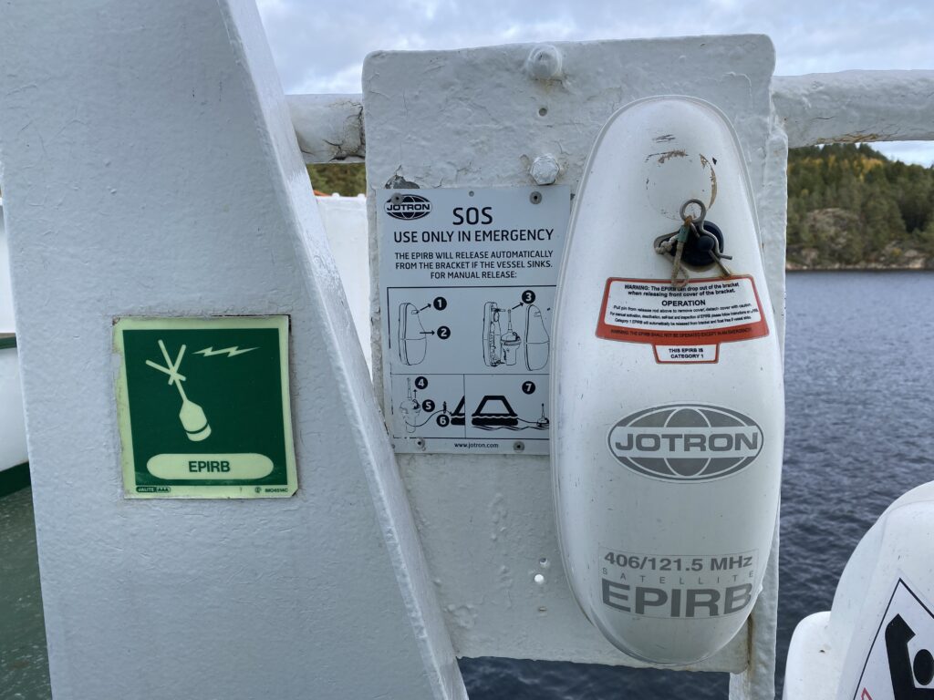
EPIRB (Emergency Position Indicating Radio Beacon)
EPIRB’s are an important component of GMDSS. The main purpose of a distress radio beacon such as the EPIRB is to help the search and rescue team to find survivors as soon as possible. EPIRBS’s are small, portable, and battery-powered radio transmitters that are both watertight and buoyant.
EPIRB’s transmit in the 406 MHz channel and on 121.5 MHz international aeronautical distress frequencies using a distinctive swept audio tone signal. A particular type of EPIRB is a PLB(personal locator beacon) which is normally smaller and shorter battery life. Aircrafts used ELB(emergency locator beacon) and ELT(emergency locator transmitter) as their EPIRB.
They are tracking transmitters that aid in the detection and location of boats, aircraft, and people in distress. Its signal allows a satellite local user terminal to accurately locate the EPIRB accurately from within 1 to 2 nautical miles as well as identify the vessel anywhere in the world.
These devices are detectable not only by COSPAS-SARSAT satellites which are polar orbiting but also by geostationary weather satellites.
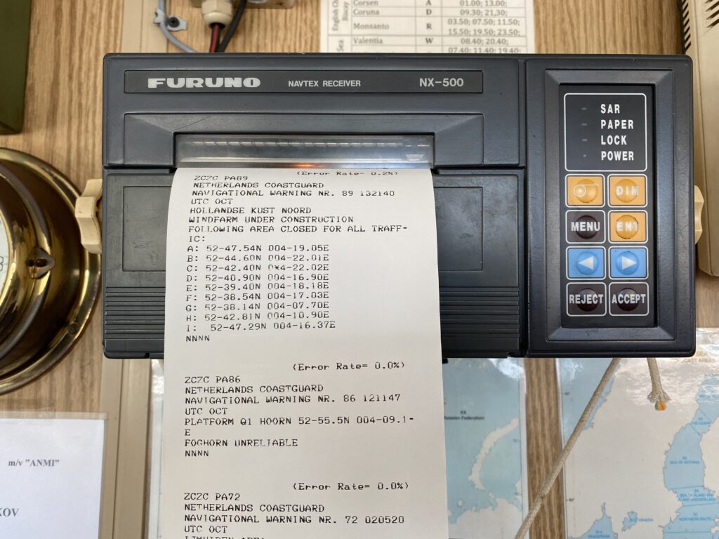
NAVTEX Receiver
Maritime Safety Information includes navigational and meteorological warnings, forecasts, dangers to navigation, and information on missing vessels and persons. The NAVTEX receiver is equipment that can receive such information and provides bridge officers latest updates.
NAVTEX(navigational telex) receiver can be used by ships of all types and sizes. This equipment prints out navigational and meteorological warnings and forecasts to ships. It can receive as far as 400 nautical miles from the broadcast station.
NAVTEX works on frequency 518 kHz in the medium frequency band as well as 490 kHz frequency in some countries. At times, transmissions are made on 4209.5 kHz. The whole Earth is divided into 21 NAVAREAS for the purpose of distributing this information.
SART
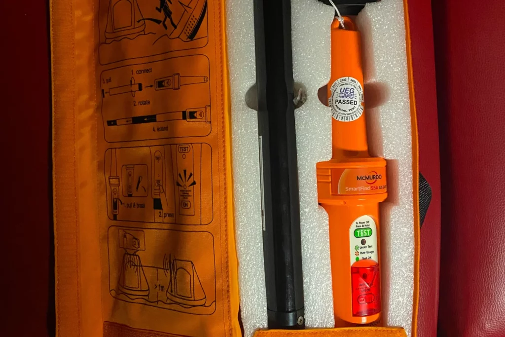
SARTs are an important part of the GMDSS system. It is used to locate a survival craft or a distressed vessel by creating a series of dots and arcs on the rescuing ship’s radar display. SARTs are made of waterproof components which protect them against damage by water.
SARTs are battery-operated equipment and can be operative for a long period of time. They can be used in ships, lifeboats, and liferafts. It is also designed to be buoyant and can remain afloat on the water for a period of time in case a vessel capsizes or is submerged in water.
SART signal can be detected on Marine 3 cm/X-band radar that works on 9 GHz. The signals used are Calle homing signals. SART is recommended to be mounted on a bracket on the highest point for maximum range and reception.
Digital Selective Calling
Digital Selective Calling or DSC is available on High-frequency radios, medium-frequency radios, and very high-frequency radios. Its main purpose is to initiate ship-to-ship, ship-to-shore, shore-to-ship radiotelephone, and radio telex calls. DSC calls can be made to individual stations, groups of stations, and all stations.
All DSC-equipped vessels or shore station is assigned a unique 9-digit MMSI (Maritime Mobile Service Identity) number. All DSC alerts which consist of a formatted distress message are used to initiate emergency communications with ships and rescue coordination centers.
Digital selective calling was intended to eliminate the need for bridge officers as well as those on shore to continuously monitor radio receivers in VHF/HF/MF equipment. MF/HF radios with DSC capability are required to be externally connected to a GPS receiver for accurate location information during distress.
All GMDSS equipment is required to be powered from multiple sources of supply. These include the ship’s normal generator, emergency generator, and a dedicated radio battery supply.
- Types of Gas Carriers as per IGC Code – April 22, 2025
- Wind-Assisted Propulsion Systems (WAPS): A Game Changer for Maritime Decarbonization – February 6, 2025
- 10 Boat Salvage Yards in California – January 25, 2025


